Yesterday, an eruption on Whakaari led to injuries and loss of lives. Our thoughts are with the whanau of those affected by this tragic event. We have been getting a lot of inquiries about this eruption, so we decided to write up what we know about the seismology associated with this eruption.
Whakaari is a volcano that is part of the Taupo Volcanic Zone, and forms a small island in the Bay of Plenty.
As far as we can tell, none of the Ru stations recorded the signals associated with the eruption, but GEONET operates seismic stations on the island:
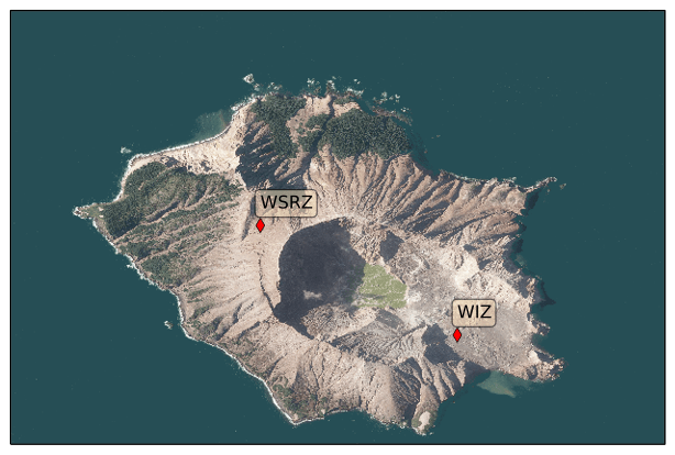
The seismic data for station WIZ are plotted below. We annotated the time of the eruption. You can see that in the day(s) leading up to this, there were some small spikes in the data indicative of small local earthquakes. In addition, we can see a few hours of low-amplitude “rumbling” of Whakaari on the 8th of December:

Seismic station WSRZ is closer to the top rim of the volcano, and recorded this:

It looks like the amplitudes of the seismic signals were elevated on the 7th and 8th of December, but things actually calmed down on the 8th before the eruption… After the eruption, small impulsive signals may be from brittle failure of the rocks (small earthquakes).
It is difficult — if not impossible — to predict volcanic eruptions, and even after the fact it is hard for us to say whether signals prior to the eruption were out of the ordinary for Whakaari. The experts at GNS have had a elevated warning in place for Whakaari since October, based on seismic signals such as these, and gas sensing. In addition, an M5.9 earthquake at 115 km depth occurred on November 24th with its epicentre about 10km from Whakaari. As with all geological tragedies such as these, we hope we can learn more about the rumblings of Rūaumoku, reducing risk in future calamities.